The Pacific Ocean: 250 Years of Maps (1540–1789)
Bounded by five continents, the Pacific Ocean is Earth’s largest feature—but it was generally unknown to Europeans until Spanish explorer Vasco Nuñez de Balboa sighted it in 1513 from a peak in Darién, Panama.* In 1516, Peter Martyr d’Anghiera, Italian-born historian of Spain during the Age of Exploration, published the first account of Balboa’s achievement. The first English version appeared in The Decades of the Newe Worlde or West India, a translation by a Tudor England nobleman’s secretary named Richard Eden that was not published till 1555. Here is his rendition, with the spelling modernized, of Martyr’s description of Balboa’s seminal moment on that mountain:
But at the length, the seventh day of the Calendes of October [September 25], he beheld with wondering eyes the tops of the high mountains, showed unto him by the guides of Quarequa, from which he might see the other sea so long looked for, and never seen before of any man coming out of our world. Approaching therefore to the tops of the mountains, he commanded his army to stay, and went himself alone to the top, as it were to take the first possession thereof. Where, falling prostrate upon the ground, and raising himself again upon his knees, as the manner of the Christians is to pray, lifting up his eyes and hands toward heaven, and directing his face toward the new found south sea, he poured forth his humble and devout prayers before almighty God. . . . (p. 90, verso, of the first book of the Second Decade)
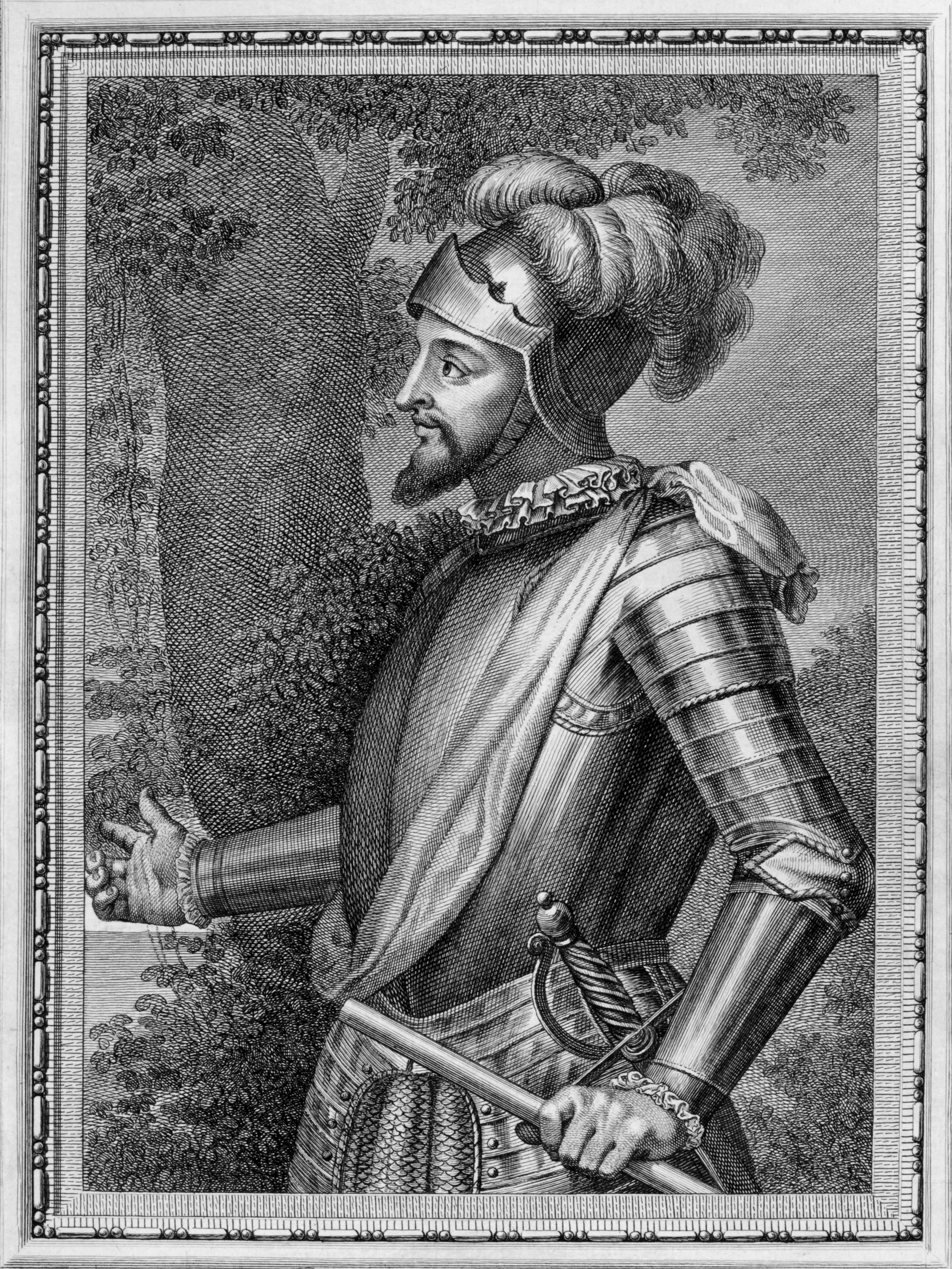
Portrait of Vasco Nuñez de Balboa. From Retratos de los Españoles ilustres, con un epítome de sus vidas (Madrid, 1791). [Rare Books Division]
Despite, or perhaps because of, the magnitude of his discovery,** Balboa quickly fell victim to Spanish New World power struggles. In 1519, he was found guilty of treason by his father-in-law, the region’s new governor, and was literally axed. The next year, a Spanish expedition led by the Portuguese explorer Ferdinand Magellan sailed into the ocean Balboa had called mar del sur (the South Sea) because of its southern orientation from the Isthmus of Panama. Magellan found the ocean calm and named it the Pacific, albeit prematurely, given the tempestuous experiences of most explorers who followed in his wake through the strait he pioneered. It would be another 250 years before the English sea captain James Cook could adequately map the realm of Balboa’s vision.
*Certainly, German cartographer Martin Waldseemüller’s historic 1507 world map strongly suggests that other Europeans had seen and/or known about the Pacific Ocean before Balboa. But his is the first documented European sighting.
**In the context of this website, the use of the word discovery (discover/discovered) is obviously Eurocentric, meaning the first time something entered European consciousness.[Click on the maps below for high-resolution images]
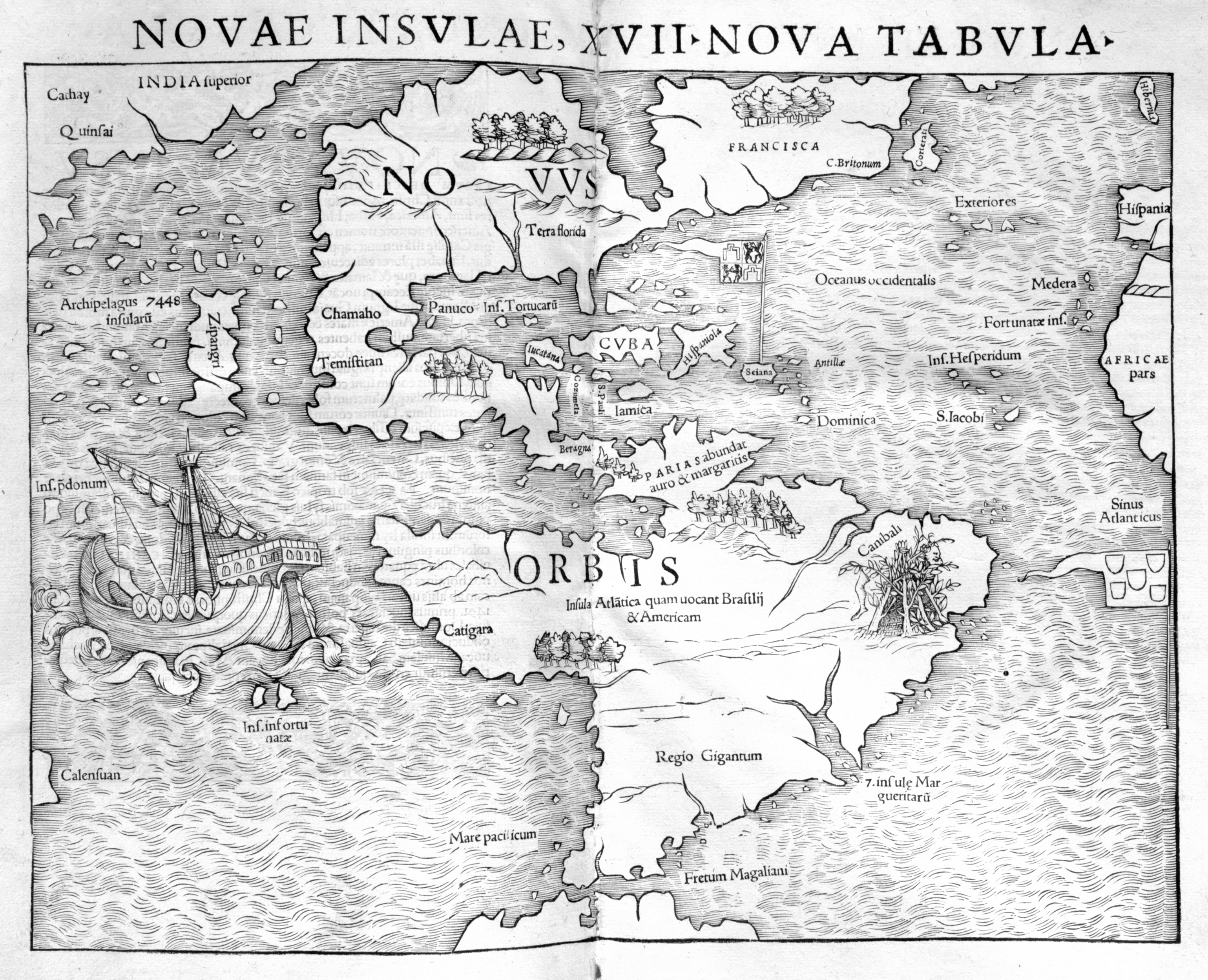
First printed map to name the Pacific Ocean. The proliferation of editions of Münster’s Geographia and his more popular work, Cosmographia, which used the same map, helped establish the name of the ocean, which was first mentioned by Antonio Pigafetta, Magellan’s surviving chronicler: “During those three months and twenty days, we sailed in a gulf where we made a good four thousand leagues across the Pacific Sea, which was so rightly named. For during this time we had no storm. . . .”*
Here, Magellan’s only surviving ship, Victoria, sails on that ocean. Marco Polo’s Zipangri (Japan) and archipelago of 7,448 islands are shown several years before any European contact. Münster locates Calensuan, a mythical island usually found in the Indian Ocean and the only Pacific land not taken from Magellan or Polo, at the western border of the map—possibly believing that the Pacific was the “Great Gulf” of the Indian Ocean shown in maps by Claudius Ptolemy, hence placing the island in roughly the same area.
As permitted by the Treaty of Tordesillas (1494), the flag of Spain flies over its Caribbean possessions, the Portuguese flag over the South Atlantic. (For more about such lines of demarcation, see the Spice Islands section.)
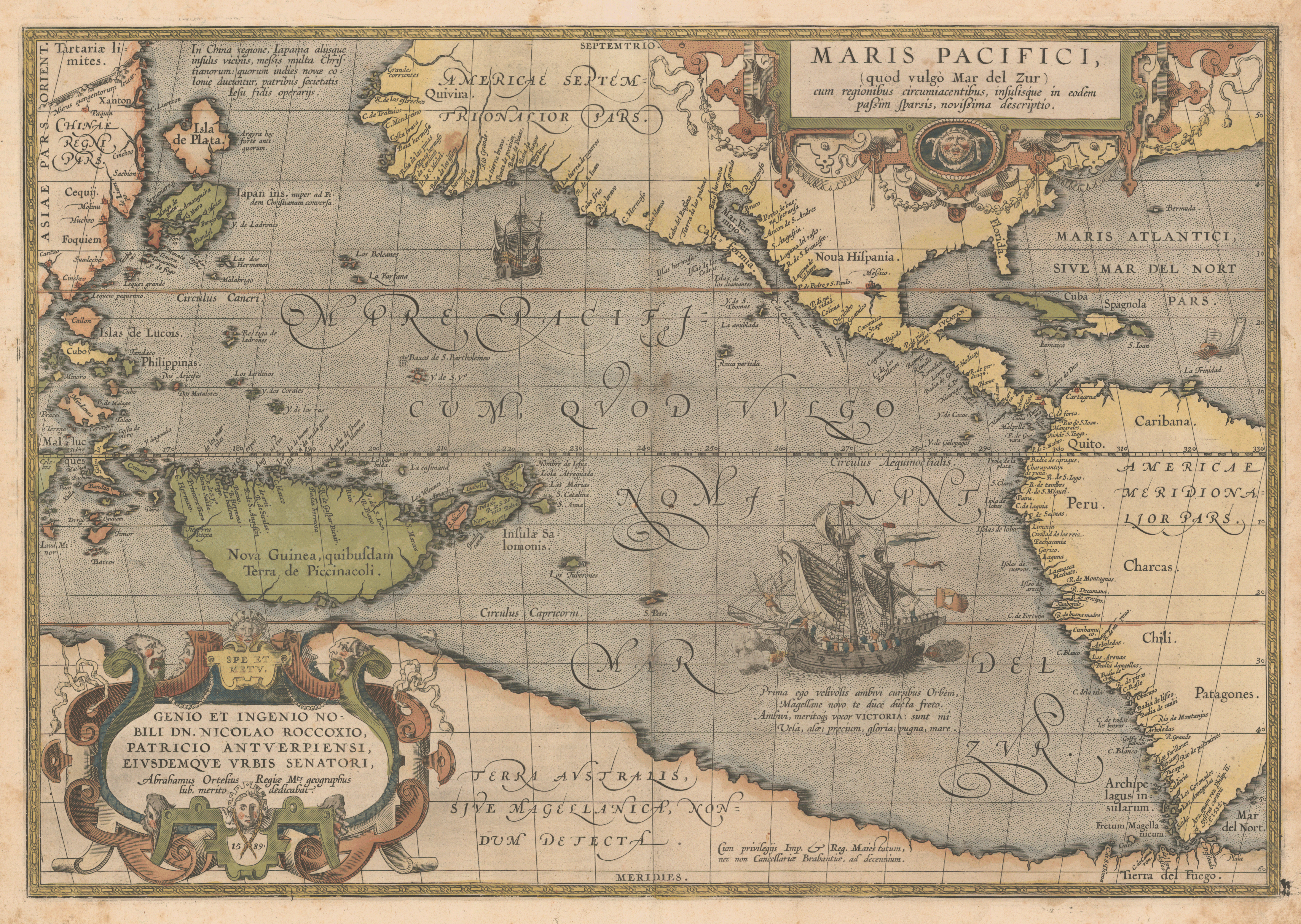
First printed map devoted to the Pacific Ocean. Engraved in (and dated) 1589, this map initially appeared in the 1590 Additamentum to Ortelius’s famous atlas, the first collection of uniformly sized maps. The exhibited copy comes from the 1595 Latin edition of the atlas, but the map is unchanged.
Two striking features are the stretched width of North America and the dominant size of a conjectured southern continent, Terra Australis. The map reflects the circumnavigation of Ferdinand Magellan (d. 1521), which more correctly established the extent of the Pacific Ocean, and shows the Solomon Islands (near New Guinea), recently discovered by the Spaniard Alvaro de Mendaña de Neira (1542?–1595) in 1568. Victoria, the only ship to complete the Magellan circumnavigation, sails proudly on the sea with cannons booming. (For more on the ship, see the Victoria box in the Magellan part of the Explorers section.) Numerous place names dot the western coasts of North, Central, and South America, indicative of Spanish colonial expansion. The only date on the map appears in a note at the bottom of South America, which states that Spanish King Philip II ordered a castle to be built there in 1582.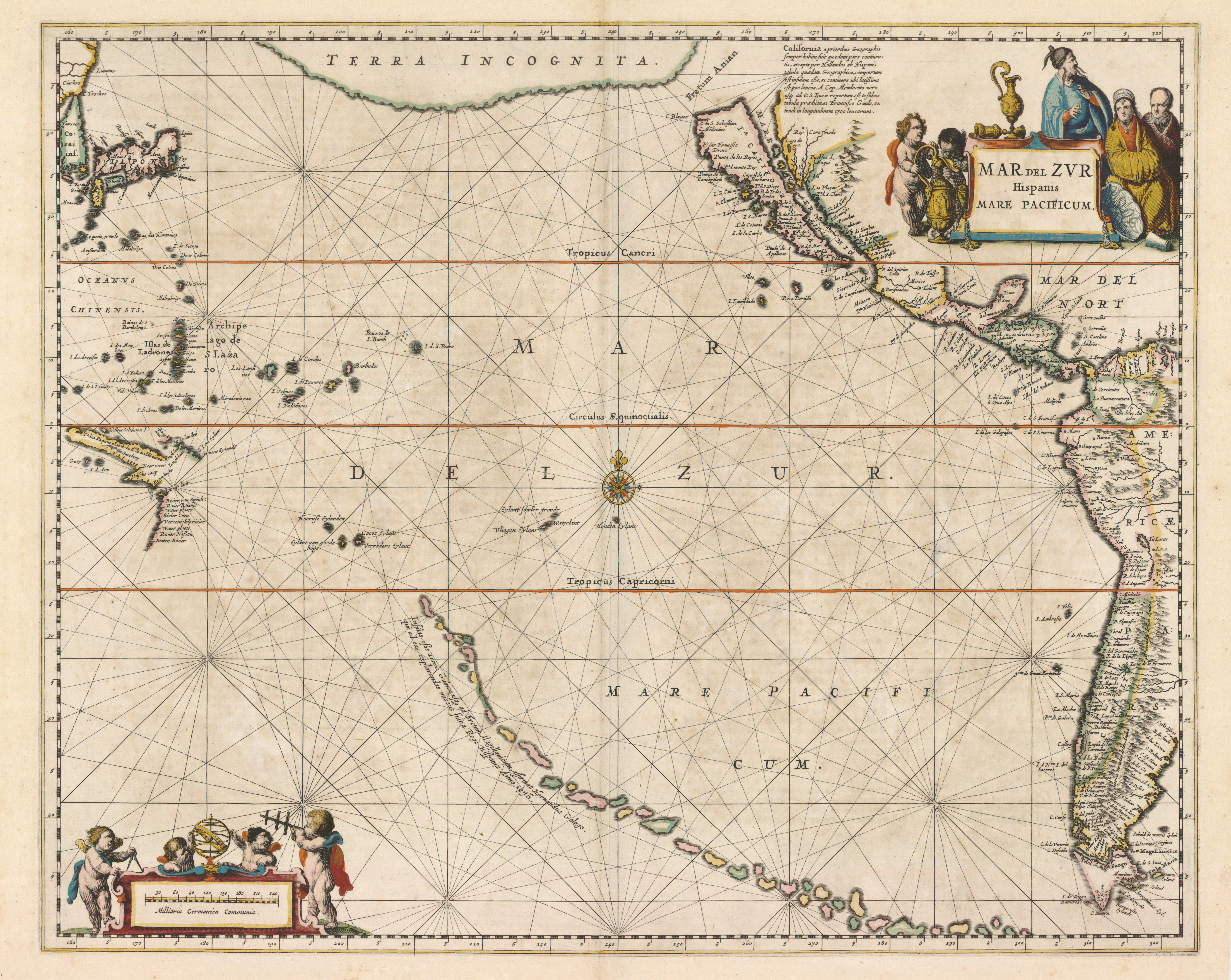
First printed chart of the whole Pacific Ocean and the first map from a Dutch atlas to show California as an island. (See Le Maire and Schouten in the Explorers section for the first printed world map [1622] to show California as an island.)
Islands spreading like a trail of crumbs follow a northwest route across the bottom, replacing the previous coastline of a fabled southern continent. Jansson attributes them to Hernán Gallego, pilot of the first Pacific expedition (1567–69) of the Spanish explorer Alvaro de Mendaña de Neira. Notice, however, that the Solomon Islands have disappeared, probably because Mendaña could not find them again many years later on his second expedition (1595–96). The map locates some of the mid-ocean island discoveries of the Dutchmen Jacques Le Maire (1585–1616) and Willem Corneliszoon Schouten (d. 1625), who were the first to round Cape Horn (that is, not to use the Strait of Magellan to reach the Pacific), which is shown here as a cape, not yet the island it is.
The myth that California was an island was introduced in a 1620 published account by Carmelite friar Antonio de la Ascensión, who, in traveling around California with a Spanish expedition and not seeing any large rivers, had deduced that the territory could not be part of a continent. Baja California, hence, became the island of California on many subsequent maps. In 1747, King Ferdinand VI of Spain stamped out the misconception by royally decreeing “California is not an island.
Goos was an important engraver, cartographer, and bookseller in Amsterdam. Many of his maps were in the form of “pascaertes/paskaertes,” or sea charts, that were targeted for ship pilots, mariners, and merchants. As one might expect, their survival rate is low.
Dated 1663, this map was prepared in advance of the first known edition of the Goos atlas. (Exhibited is the very rare first state of the map; only one other copy is known—most are redated 1666.) North is oriented to the right. Most of California appears, as an island, with a northern shore containing two bays. These are located adjacent to the fabled Strait of Anian (Straet Anian) or Northwest Passage, which Europeans believed was a navigable northern passage between Europe and Asia. A notable feature of the map is the great separation between North America and Asia in the north. By Captain James Cook’s time this would close considerably.
In the South Pacific region, the 1642 discoveries of New Zealand and Tasmania (Van Diemen’s Land) by the Dutchman Abel Tasman (1603?–59) are presented. The Mariana Islands (Magellan’s Ilhas de Ladrones) are correctly featured at the top (west), while Land van Eso(Kamchatka) borders a mysteriously incomplete Compagnies Land, which is actually one of the Kuril Islands.
A regressive map, featuring the track of English privateer Thomas Cavendish (1560–1592), the third circumnavigation in history, after Ferdinand Magellan and Sir Francis Drake. More of a buccaneer’s adventure than an explorer’s expedition, Cavendish’s voyage added nothing geographically; hence, the map seems somewhat archaic for its period. California is still depicted as an island, and the great gap between Asia and North America remains, though the contours of North America have improved. There are no indications of the voyages of Abel Tasman (1642, 1644) or William Dampier (1699–1701)—and no Australia, Tasmania, New Zealand.
The huge financial success of Cavendish’s voyage (he plundered numerous Spanish ships and ports en route) possibly explains the title vignette’s depiction of a sumptuous spread being enjoyed by the English crew on a generic palm-shaded island.
Considered a cartographic masterpiece of the eighteenth century, this map presents a visually arresting, encyclopedic view of the world in the Age of Exploration. As the title suggests, it focuses primarily on the South Sea (la Mer du Sud), as the Pacific Ocean was often called, beginning with Balboa in 1513. Dated two hundred years after Magellan first entered the Pacific from the east by finding and traversing the Strait of Magellan at the bottom of South America, it presents a good “before and after” view of the ocean and its lands—before the extraordinary voyages of the English navigator Captain James Cook in the 1760s and 70s, yet after the landmark expeditions of the Portuguese, Spanish, and Dutch in the previous two centuries.
Much of the map’s fascination, of course, comes from the numerous, extraordinary vignettes. Two at the top pay homage to the industrious beaver and the cod industry, emphasizing the natural resources that were the basis of North American colonial economies. There are medallion portraits of nine explorers, from Christopher Columbus (ca. 1451–1506), the Genoese discoverer of “le Nouveau Monde,” to Robert Cavelier, sieur de la Salle (1643–87), who claimed the Mississippi River watershed for France. California-as-an-island, a very late representation here, bears a qualifying note admitting that some (“Modernes” thinkers) believe it is connected to the continent.
The bottom half of the map bears more scrutiny. From the left, there are depictions of Peruvians transporting gold and silver on llama-back (for the Spanish); scenes in the life of “Canadiens,” presumably North American Indians (peace signing, dancing, feasting, marrying, dying); mining; sugar milling; and human sacrifice. Exotic native fruits (banana, coconut, watermelon, papaya), birds (eagle, flamingo), and animals (armadillo, opossum) decorate the tableaux. On the bottom right are featured plans of major commercial ports in the West Indies and South America: Río de La Plata, Havana, Rio de Janeiro, and Vera Cruz. The various uses of the important cassava plant are shown.
What is lacking, of course, is much representation of Pacific lands and islands, along with their flora, fauna, and peoples. (Remember the title of the map?) These remain to be “discovered” by Europeans. Dutchman Abel Tasman’s explorations (1642, 1644) to Van Diemen’s Land (Tasmania) and New Zealand are present but practically hidden in the curves of the pictorial designs; his name is absent. The South Sea, itself, is almost empty, except for the Solomon Islands, whose misplacement in mid-ocean would keep them lost until they were rediscovered near New Guinea by the Englishman Philip Carteret in 1767. In effect, the map takes stock of the world that was still unfolding at the beginning of the eighteenth century. By offering a lavish potpourri of curious, strange, and interesting New World images, with accompanying historical commentary, the map both engages the senses and instructs the minds of its European audience.
An impressive but outdated nautical chart produced by France’s Depot de la Marine (see its mark in the lower left). Earlier versions appeared in 1742 and 1756. Yet, despite the title note that “cette carte a eté corrigée en 1776,” there is not much difference in the map from its pre-Cook versions, particularly for the region below the equator. In fact, at a quick glance, one might consider this map to be a “BC” (that is, before Cook) view of the Pacific. For there is no evidence of the two New Zealand islands charted on Cook’s first voyage (1768–71), nor of his Australian coastal itinerary, including passage along and through the Great Barrier Reef. A closer look, however, reveals that the cartography is even older. The latest date on the map is 1716, given for an island discovered off of Japan. Dutchman Jacob Roggeveen’s Easter Island (1722) is not here, and the Solomon Islands still bear the wrong longitudes—thus remaining “lost” to navigators.
An Austrian version of a map originally issued by Daniel Djurberg in Stockholm, Sweden, in 1780 as the first Swedish work to show Captain James Cook’s discoveries. Hence this is a good post-Cook view of an expanded Pacific area. It tracks the routes of a number of earlier explorers as well, including John Byron, Louis-Antoine de Bougainville, Jacques Le Maire, Pedro Fernandes de Queirós, Abel Tasman, and Samuel Wallis. Australia is called by its New Zealand Maori name, Ulimaroa. Its delineated eastern coastline benefits from Cook’s exploration in the Endeavour during his first voyage. Roggeveen’s Easter Island is shown in the inset. And Cook’s Sandwich Islands (today’s Hawaii) finally make an appearance, in the upper right, next to the cartouche.
Granted, there is still much to identify and correctly locate here—but the realm of Balboa’s 1513 South Sea has been cartographically realized.