Terra Australis
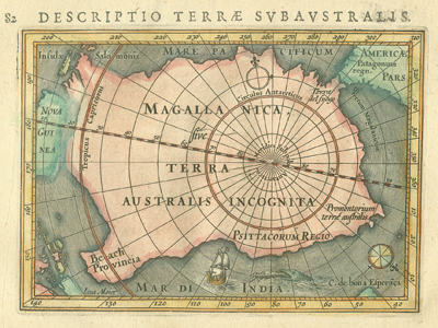
“Descriptio terræ subaustralis.” Copperplate map, with added color, 9 × 13 cm. From Petrus Bertius’s P. Bertii tabularum geographicarum contractarum (Amsterdam, 1616). [Historic Maps Collection]
An early seventeenth-century view of the undiscovered southern continent.
With little or no evidence to confirm its existence, a vast southern continent (Terra Australis, “land of the south”) still figured prominently on European maps from the fifteenth to eighteenth centuries. The Greek philosopher Aristotle introduced (deduced) the idea that the earth had to be balanced: the northern mass (Arctic) must have a southern counterpart. Moreover, such a continent must extend into the temperate zone. The Greek cartographer Ptolemy began to codify the concept on his influential maps by showing the Indian Ocean enclosed by Africa, India, and a southern land. Bartolomeu Dias’s rounding of Africa’s Cape of Good Hope in 1488 only pushed the continent further south in the eastern hemisphere. After Ferdinand Magellan passed through the Strait of Magellan in 1520, mapmakers considered its southern side, often called Magellanica, to be part of the landmass that they had conjectured. Willem Corneliszoon Schouten and Jacques Le Maire’s 1616 expedition around South America’s Cape Horn had a “Dias” effect on subsequent western hemisphere maps: the southern land fell further south. Before Abel Tasman sailed “under” it in 1642, Australia held promise as the temperate part of such land.
The hypothetical continent, named Terra Australis Incognita on many maps, continued to change shape and size—often having no distinct shorelines—as European exploration of the Pacific Ocean advanced through the seventeenth and eighteenth centuries. The systematic search by Captain James Cook on his second voyage in the 1770s finally proved that such land, by then greatly diminished, would only be found in the cold, uninhabitable, polar regions. That set the stage for the nineteenth- and twentieth-century European pursuit of Antarctica and the South Pole.
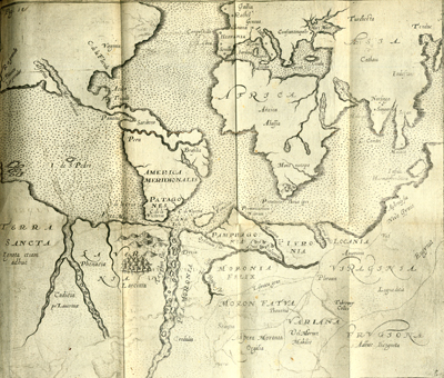
Untitled copperplate map, 20.7 × 24.5 cm. From Joseph Hall’s Mvndvs alter et idem siue Terra Australis ante hac semper incognita longis itineribus peregrini academici nuperrime lustrata (Frankfurt, 1607?). [Rare Books Division]
Bishop Joseph Hall of Norwich, England, mocked the idea of the southern continent in his book about the discovery of a new world. His satire included this world map, in which he divided Terra Australis into areas called Tenter-belly, Shee-landt (Womandecoia), Fooliana, and Theevingen, with provinces like Eat-allia, Drink-allia, Double-sex, Asse-sex, Cocks-combaya, and Shrewes-bourg.

