“The Pilgrims Progress, or, Christians Journey from the City of Destruction in This Evil World to the Celestial City in the World That Is to Come” ([London]: Published . . . by J. Pitts, no. 14 Great St. Andrew Street Seven Dials, July 1, 1813). Copperplate map, with added color, 34 × 45 cm, on sheet 41 × 51 cm [Historic Maps Collection].
This anonymous map visually interprets English preacher John Bunyan’s religious allegory The Pilgrim’s Progress from This World to That Which Is to Come: Delivered Under the Similitude of a Dream, Wherein Is Discovered the Manner of His Setting Out, His Dangerous Journey, and Safe Arrival at the Desired Countrey (1678). (The book was probably written during his imprisonments for preaching without a license.) The protagonist, named Christian, faces temptations and digressions that could prevent him from reaching his goal, God’s celestial city. The symbolic nature of the work lends itself to graphic illustration: the Slough of Despond, the Valley of the Shadow of Death, Vanity Fair—such “obstacles” have become iconic in Western literature. The universal resonance of Bunyan’s work—it has been translated into more than two hundred languages—accounts for its never having been out of print.
Lewis Carroll, 1832–1898. “Ocean Chart.” Printed map, 13 × 8.2 cm. From Carroll’s The Hunting of the Snark: An Agony in Eight Fits (London: Macmillan, 1876) [Rare Books Division]. With nine illustrations by Henry Holiday. Lewis Carroll, of course, is the pseudonym of Charles Lutwidge Dodgson, author of Alice’s Adventures in Wonderland (1865).
Imagination at its most sublime and amusing: a blank map bearing only the accoutrements of orientation and an inscrutable scale.
He had bought a large map representing the sea,
Without the least vestige of land:
And the crew were much pleased when they found it to be
A map they could all understand.
‘What’s the good of Mercator’s North Poles and Equators,
Tropics, Zones, and Meridian Lines?’
So the Bellman would cry: and the crew would reply,
‘They are merely conventional signs!’
‘Other maps are such shapes, with their islands and capes!
But we’ve got our brave Captain to thank’
(So the crew would protest) ‘that he’s bought us the best—
A perfect and absolute blank!’
[pp. 15–16, from “Fit II. The Bellman’s Speech”]
Portrait of Albert Robida, 1848–1926, by A. Brauer. From vol. 1 of Figures contemporaines tirées de l’Album Mariani (Paris: Ernest Flammarion, 1894) [General Library Collection].
Frenchman Albert Robida is the father of science fiction illustration. Though he trained to be a notary, he supported himself as an illustrator and caricaturist. He cofounded his own magazine, Le Caricature, in 1880, and authored a trilogy of futuristic novels: Le vingtième siècle (1883), La guerre au vingtième siècle (1887), and Le vingtième siècle: La vie électrique (1890). In these, he has often been compared to his contemporary countryman Jules Verne, whose own futuristic works such as (in English) Journey to the Center of the Earth (1864) and Twenty Thousand Leagues under the Sea (1869) pioneered the genre. However, Robida’s characters were not mad scientists, and his prescient imagination was more attuned to everyday life; his inventions, as a result, had social implications and consequences. For example, he envisaged wars fought with missiles and poison gas, flat-screen televisions that provided twenty-four-hour views of remote events, and urban settings that included flying cars and electric trains.
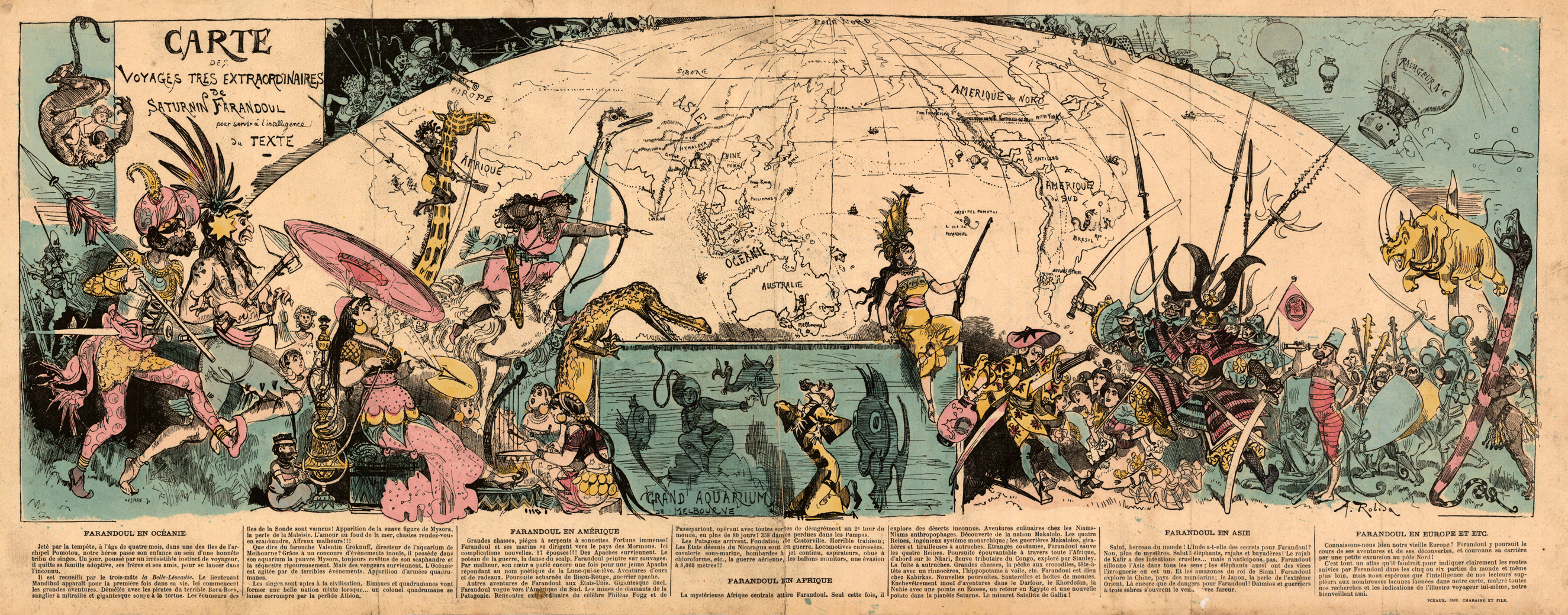
[Below] “Carte des voyages très extraordinaires de Saturnin Farandoul: Pour servir a l’intelligence du texte.” Lithograph map, with added color, 21.5 × 65 cm. From Robida’s Voyages très extraordinaires de Saturnin Farandoul: Dans les 5 ou 6 parties du monde et dans tous les pays connus et même inconnus de M. Jules Verne (Paris: Librairie illustrée, [1879]) [Historic Maps Collection]. The 808-page book includes 453 drawings and 50 full-page color illustrations.
World map from Robida’s first novel. Farandoul’s adventures were serialized weekly, collected and published in five parts or books, and finally gathered into one large volume; the map first appeared in the first book. As one might expect from the title, Robida’s work is a spoof on Jules Verne’s “extraordinary voyages” series—in fact, the second part is titled “Le tour du monde en plus de 80 jours,” a clear reference to Verne’s Around the World in 80 Days (1872). The map gives the reader a robust sense of the rollicking, continental range of Farandoul’s world tour—and the exotic, formidable peoples and creatures he encounters—from his survival at the age of four months and seven days from a shipwreck on a remote Pacific island to his return years later as a grown man.
William Faulkner (1897–1962). “Jefferson, Yoknapatawpha Co., Mississippi.” Printed map, 27 × 24.4 cm. From Faulkner’s Absalom, Absalom! (New York: Random House, 1936) [Rare Books Division].
Probably the most famous map in American literature, bearing the statement “William Faulkner, Sole Owner & Proprietor”—in case there were any doubt of its authenticity. It is based on Oxford, Lafayette County, Mississippi, where Faulkner lived for most of his life, and locates much of Faulkner’s fiction. Leading up to this novel were the remarkable achievements of The Sound and the Fury (1929), As I Lay Dying (1930), Sanctuary (1931), and Light in August (1932)—all have incidents in Yoknapatawpha, and so the map is not as much a revelation to readers as it is a confirmation of what they have learned from the previous fiction. Faulkner received the Nobel Prize for Literature in 1949.
Dust jacket cover of Faulkner’s Absalom, Absalom! (New York: Random House, 1936) [Rare Books Division].


