Sir Francis Drake, 1540?–1596
Expedition (1577–1580): Five ships (Pelican [renamed Golden Hind], Elizabeth, Marigold, Swan, Christopher [a sixth, Mary, was later captured and added]), 164 men
Charge (by Queen Elizabeth I of England): To raid Spanish ports along the Pacific coast of the Americas and disrupt the flow of gold and silver to Spain
Accomplishments: First English circumnavigation of the world (second after Magellan), returning with a rich cargo of spices and captured Spanish treasure
Legacy of Drake’s name: Drake Passage (between South America and Antarctica), Drake’s Bay (California)
[Click on the images below for high resolution versions.]
Great Britain’s rise as a major sea power began with Drake, the most famous of the country’s three earliest circumnavigator-buccaneers (the others were Thomas Cavendish and William Dampier). The eldest of twelve sons born to Edmund Drake, tenant farmer, and his wife, Mary Mylwaye, in Devon, England, Drake started his sea career before he was thirteen, as an apprentice aboard a bark plying the trade across the English Channel. By twenty, he was master of the ship; before thirty he had voyaged to the New World several times on ships owned by his relatives, the Hawkins family of Plymouth. In 1568, he suffered a harrowing escape from a treacherous Spanish attack on the Hawkins’s fleet in the Mexican port of San Juan de Ulúa. Drake’s reaction was a lifelong hatred of the Spanish. In the next few years, he took his revenge by plundering Spanish settlements, shipping, and gold-laden mule trains in Panama, sometimes teaming up with local pirates. He was a wealthy man when he returned to Plymouth in 1573. By then, he was known as El Draque in Spanish (later, in Latin, his name would be published as Franciscus Draco, Francis the Dragon).
While tension between Spain and England increased in the 1570s, the quest for a Northwest Passage attracted English commercial interests. Queen Elizabeth I saw an opportunity to use Drake’s leadership, navigational skills, and knack for adventure—ostensibly sending him up the west coast of South America on an expedition to harass Spanish ports and to seize treasure, but also secretly charging him to search for a Northwest Passage from the Northwest coast of North America. Drake left England in the late fall of 1577 with a fleet of five ships (a sixth was added when it was captured from the Portuguese off Africa) but quickly suffered a great attrition: by the time he reached the Pacific Ocean (September 1578), only the flagship Pelican remained. For the next month or more, Drake’s ship was blown far to the south and east by a series of gales, to a point where he could see no more islands and no great continent, suggesting a confluence of the two oceans. This was the Drake Passage between South America and Antarctica, named in his honor and later confirmed by the Dutch explorers Jacques Le Maire and Willem Corneliszoon Schouten. The Pelican was battered but not broken.
Portrait of Sir Francis Drake. Frontispiece to his nephew's The World Encompassed . . . (London, 1628) [Rare Books Division].
Drake’s fortunes quickly improved. Renaming his ship the Golden Hind, Drake pushed north along the coasts of Chile and Peru, attacking Spanish interests; he also acquired more accurate charts from captured Spanish ships. His most profitable prize was the Nuestra Señora de la Concepción (also called the Cacafuego), which he seized at the beginning of March 1579 as it was sailing west toward Manila in the Philippines. The Spanish ship’s treasure included eighty pounds of gold, thirteen chests of coins and jewels, and more than twenty-five tons of silver, the equivalent of millions of dollars today.
On the west coast of North America, Drake explored further north than Spain’s claim at Point Loma (near today’s San Diego, California). How far north he went has been the subject of much contention. Only two pages in the published account (1628) of his voyage cover the two mysterious months (April 16–June 17, 1579) in which Drake sailed from Guatulco (today’s Huatulco, south of Acapulco, Mexico) to 48° N, then came south to a small port on the Pacific coast of America at 38° N, where he repaired his boat and rested before returning home. From his sparse descriptions of the coastal landmarks and the freezing weather (“frozen Zone”) he and his men encountered, some modern scholars theorize that Drake probably reached 57° N, around Prince of Wales Island (in today’s Alaskan chain of islands off British Columbia), and also explored Vancouver Island and the Strait of Juan de Fuca. Claiming the territory for England, Drake named it Nova Albion, a reference to and reverence for his country’s earliest name, Albion.
Drake receiving the Crown from the Hioh, or King of New Albion.” From David Henry’s An Historical Account of All the Voyages Round the World, Performed by English Navigators . . . (London, 1774), vol. 1. [Cotsen Collection]
. . . [T]he King, with the concurrence of the rest, placed the Crown upon Drake’s head, graced him with the chains and other signs of authority, and saluted him with the title of Hioh. The kingdom thus offered, though of no farther value to him than that it furnished him with present necessities, Drake thought it not prudent for him to refuse; and, therefore, took possession of it in the name of Queen Elizabeth, not without ardent wishes that this acquisition might be of use to his native country. [p. 123]
Note the incongruous palm tree in the background.


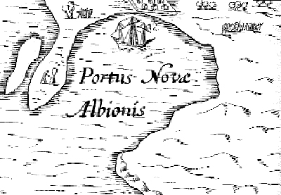
An aerial view of Whale Cove, Oregon (44°44' N), contrasted with the “Portus Novæ Albionis” inset of Jodocus Hondius’s world map, ca. 1595. [Both images from Wikipedia]
Some scholars theorize that this is the harbor described by Drake where the Golden Hind was anchored and repaired (June 17–July 23, 1579) in what he called “New Albion.” The theory was proposed by Robert Ward in 1981 ("Drake and the Oregon Coast," The Geographical Magazine). Though Drake gives its latitude as 38°30′ N, Samuel Bawlf argues (The Secret Voyage of Sir Francis Drake, 2003, which borrows heavily from Ward's earlier research) that all of Drake’s northern coordinates were deliberately reduced by ten degrees to mislead the Spanish about the true northern extent of his travels. In addition, the cove matches the visual representation on Jodocus Hondius’s world map “Vera Totius Expeditionis Nauticæ . . .” (ca. 1595) of the inset of “Portus Novæ Albionis,” for which Drake had supplied the drawing; Bawlf suggests that no other cove along the California/Oregon coast has these same characteristics. (A portion of the peninsula is submerged at high tide, creating the additional “island.”) More recently, Garry Gitzen (Sir Francis Drake in Nehalem Bay 1579, 2008) has posited Nehalem Bay, Oregon, as the true New Albion, using multifaceted approaches (such as topography, ethnology, flora/fauna, geography). In either view, Oregon seemed a more likely location for Drake's careening respite—not California. In 2012, after years of conducting its own review of the research, the Department of the Interior designated Drake's Cove in Drake's Bay, California, as a National Historic Landmark, though it did not take sides in the continuing debate.
At his anchorage, Drake summarized his thoughts about the possibility of a Northwest Passage:
. . . [W]e conjecture that either there is no passage at all through these Northerne coasts (which is most likely) or if there be, that yet it is unnavigable. Adde hereunto, that though we searched the coast diligently, even unto the 48. deg. yet found we not the land, to trend so much as one point in any place towards the East, but rather running on continually Northwest, as if it went directly to meet with Asia; and even in that height when we had a franke wind, to have carried us through, had there beene a passage, yet we had a smooth and calme sea, with ordinary flowing and reflowing, which could not have beene, had there beene a strete: of which we rather infallibly concluded then conjectured, that there was none. [The World Encompassed . . . , p. 67]
Two hundred years later, exploring the Northwest coast of North America, Captain James Cook would reach the same conclusion.
Heading westward across the Pacific, Drake reached the Moluccas (Spice Islands) within a few months and after many stops rounded the Cape of Good Hope. With a remaining crew of fifty-nine, the Golden Hind arrived in Plymouth in September 1580, its cargo rich in spices and Spanish treasure. The Queen’s share represented a substantial portion of the crown’s income that year. A national hero and European sensation, Drake was knighted for his efforts, but Elizabeth ordered a ban on publishing any details of his voyage, fearing Spain’s reaction. His original charts and journals ultimately disappeared. Drake would go on to other exploits, including having a major role in England’s defeat of the Spanish Armada in 1588, but his circumnavigation of the world remains his most important achievement. (It would be two hundred years before another Englishman, James Cook, expanded on his Pacific Northwest exploration.) Drake died of dysentery in 1596 while anchored off the coast of Portobelo, Panama, in pursuit of more Spanish treasure ships. He was buried at sea there, in full armor, encased in a lead coffin.
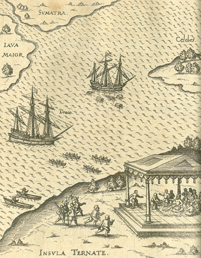
Drake’s visit to the sultan of Ternate during his circumnavigation. From Levinus Hulsius’s Sechster Theil, kurtze, warhafftige Relation vnnd Beschreibung der wunderbarsten vier Schiffahrten . . . (Frankfurt, 1626). [Rare Books Division]
[T]he third of Novembre [1579] wee came in sight of the Ilands of the Moluccaes as we desired. These are foure high piked Ilands, their names, Tirenáte, Tidóre, Matchan, Batchan, all of them very fruitfull, and yeelding abundance of cloves, whereof wee furnished our selves of as much as we desired at a very cheape rate. At the East of them lyes a very great Iland called Gillola. [Drake, p. 84]
First page of the first printed narrative account of Drake's circumnavigation. From Richard Hakluyt's The Principall Nauigations, Voiages and Discoueries of the English Nation: Made by Sea or Ouer Land, to the Most Remote and Farthest Distant Quarters of the Earth at Any Time Within the Compasse of These 1500 Yeeres: Deuided into Three Seuerall Parts, According to the Positions of the Regions Whereunto They Were Directed ... Whereunto Is Added the Last Most Renowmed [sic] English Nauigation, Round about the Whole Globe of the Earth (London, 1589). [Rare Books Division]
Twelve pages of supplementary, unnumbered text have been inserted between pages 643-644 in Hakluyt's work.
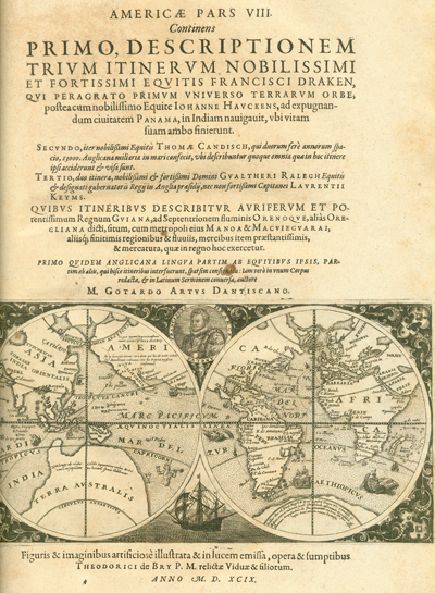
Title page of Part VIII of Theodore De Bry's Americae pars VIII. Continens primo, descriptionem trivm itinervm Francisci Draken, qvi peragrato primvm vniverso terrarvm orbe, postea cum . . . (Frankfurt, 1599). [The Scheide Library]
A later, reduced copy of the first map to trace Drake's route around the globe. In addition, it features a portrait of Drake and an image of his ship, the Golden Hind.
Drake, Francis, Sir, d. 1637 (nephew). The World Encompassed by Sir Francis Drake: Being His Next Voyage to That to Nombre de Dios Formerly Imprinted / Carefully Collected Out of the Notes of Master Francis Fletcher Preacher in This Imployment, and Diuers Others His Followers in the Same; Offered Now at Last to Publique View, Both for the Honour of the Actor, but Especially for the Stirring Up of Heroick Spirits, to Benefit Their Countrie, and Eternize Their Names by Like Noble Attempts. London, 1628. [Rare Books Division]
First detailed account of Drake’s circumnavigation, written by his nephew. Queen Elizabeth’s ban on the publication of Drake’s full account of his voyage lasted for thirty-two years after his death—until it was finally broken with the appearance of the little volume shown here. Presumably, most of those who had been privy to the true extent of the voyage were dead. (Only a limited, edited version had appeared previously.) The narrative covers the period from November 15, 1577, when Drake departed from Plymouth, England, to September 26, 1580, when he returned to the same port.
“A New and Accurate Mappe of the World, Drawne According to the Best and Latest Discoveries That Have Beene Made.” Copperplate map, 15.9 × 24.1 cm. From Drake’s The World Encompassed . . . (London, 1628). [Rare Books Division]
This double-hemisphere world map by Robert Vaughan (1592–1667) is a reduced version of one by John Speed (1552?–1629) published two years earlier. It was dropped from later editions of the book. The four elements (fire, air, water, earth) hover above the map, portraits of the first four circumnavigators (Ferdinand Magellan, Sir Francis Drake, Thomas Cavendish, Olivier van Noort) grace the sides, and diagrams of eclipses of the sun and moon appear at the bottom.
The western hemisphere map portrays California as an island, which was a very fresh concept at that time; shows some of the Tonga Islands, recently discovered (1616) by the Dutchmen Jacques Le Maire and Willem Corneliszoon Schouten and here translated as Flies Island, Waterland, Dogs Island, and an island “without ground” (anchorage); and proudly boasts that “Twice in our age” Englishmen have passed through the Strait of Magellan on their way around the world. (For more on Le Maire/Schouten, see the explorer’s section.) The most interesting note, however, relates to the vast “Southerne Unknone Land” of the eastern hemisphere map: “This South part of the World (containing almost the third part of the Globe) is yet unknown certayne sea coasts excepted: which rather shew there is a land then descry eyther land, people, or comodities.” There have been tantalizing hints (“certayne sea coasts”) of such a land but no confirmation. Future exploration would continue the hunt for this mysterious southern continent. (For more, see the Terra Australis box in the Pacific Ocean section.)


