1552
1552 map
Münster, Sebastian, 1489-1522.
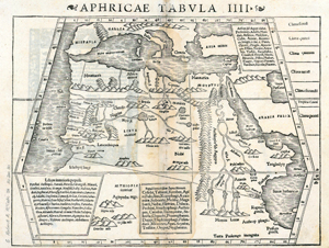
“Aphricae tabula IIII.” Woodcut map, 24 x 32 cm. From the last Münster edition (Basel, 1552) of Ptolemy’s Geographia. Gift of Robert A. McCabe, Class of 1956. [Historic Maps Collection]
A Ptolemaic map on a trapezoidal projection. Distinctive mountain groups are named, and a very long range is shown running north-south from Aegyptus (Egypt) to Aethiopia interior, where it meets the Montes Lunae (Mountains of the Moon). The area south of those mountains is labeled Terra Ptolemeo incognita (land unknown to Ptolemy). Three lakes (not the usual two of Ptolemy) are the sources of the Nile, and the Niger links two lakes in Libya interior. There is no Saharan desert. The map identifies six different climate zones for northern Africa, and the text blocks name dozens of native peoples who live in Libya, the Upper Nile (above ancient Meroë, the ruins of which are near modern Kabãsh§yah, Sudan), and Egypt.
1670
1670 map
Dapper, Olfert, 1639-1689.
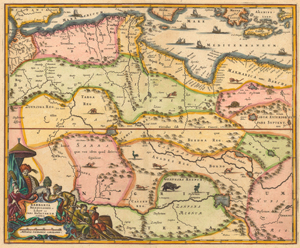
“Barbaria, Biledulgerid o: Libye et pars Nigritarum terra.” Copperplate map, with added color, 26 x 32 cm. Probably from Dapper’s Umbst~ndliche und eigentliche Beschreibung von Africa.… (Amsterdam, 1670). [Historic Maps Collection]
Dapper was a Dutch physician and geographer who based many of his descriptions on interviews with sea captains and merchants returning to Amsterdam from foreign parts. His map of northern Africa is divided into four main horizontal sections labeled in large type: Barbaria, Biledulgrid/Numidia, Libya, and Nigritarum. Barbaria contains the more familiar coastal kingdoms (Alger, Tunis, and Tripoli), as well as the desert plateau region nearer to Egypt called Marmarica. Biledulgerid is the Arab name for a date-bearing region, and Numidia was the name of the ancient Roman province in North Africa. In Arabic, Libya, the third part, is called Sarra, which means desert, although a long river, the Girus, is shown flowing through it. Perhaps it is a variant of the Niger, from ghir nigheren, meaning “river of rivers.” The fact that it flows off the map to the right, in the direction of the Nile, suggests the cartographic influence of al-Idr§s§. Nigritarum translates as “land of the black people,” so called either because of the non-Arab inhabitants, who are supposedly of a black color, or because of the river Niger (black), which flows through the region between two lakes.
The colorful cartouche area of the sheet shows brightly dressed men sporting long moustaches. But they appear more Asian than Arabic or African, for no European cartographer at this time had firsthand information about the physical features of natives in the interior.
1700
1700 map
Mortier, Pierre, 1661-1711.
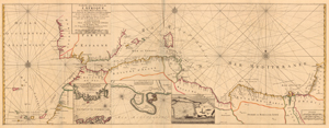
“Carte des costes de l’Afrique sur la Mer Mediterranée, et le detroit de Gibraltar, les îles de Madere et des Canaries, iusques à Tungarral.” Copperplate chart, with added outline color, 51 x 135 cm. From the third part of Mortier’s Le Neptune françois, which was separately issued and titled as Suite du Neptune françois, ou Atlas nouveau des cartes marines (Amsterdam, 1700). [Historic Maps Collection]
Descended from French emigrés, Mortier became one of the most successful and wealthiest Amsterdam map publishers of the 17th century. His maritime atlas, Le Neptune françois, consisted of lavish sea charts produced on a larger scale than the usual Dutch folio and incorporating French cartography. The sources for the maps of the third part were royal Portuguese archival manuscripts; given the extensive Portuguese mapping of African coasts, they exhibited uncommon accuracy for the period.
This large map (three sheets fitted together) covers the coastline from Tungarral (near the border of today’s Western Sahara and Morocco), facing the Canary Islands in the Atlantic Ocean, up to the Strait of Gibraltar, across North Africa, to the Gulf of Antioch (Antakya, Turkey) in the Mediterranean. The emphasis is on the names of ports, and insets of the major harbors (with soundings) at Gibraltar, Algiers, and Tripoli are provided. Rhumb lines (paths of constant compass-bearings) dominate the seas, adding to the navigational uses of the map.
1814
1814 map
Pinkerton, John, 1758-1826.
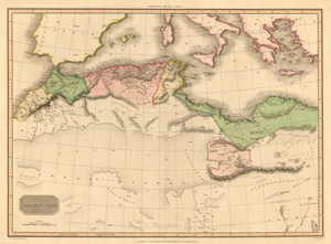
“Northern Africa.” Copperplate map, with added color, 49 x 68 cm. From Pinkerton’s A Modern Atlas, from the Latest and Best Authorities . . . (London, 1815). Gift of Bruce Willsie, Class of 1986. [Historic Maps Collection]
Pinkerton was a Scottish antiquarian who sought to purge Scottish history of Celtic influences, even if that meant forging “older” literature to prove his point. His geographic/cartographic talents, however, were admirable, and his maps are skillfully engraved and attractively designed.
The Great Desert, country of the nomadic Tuaregs, dominates this map. (Dappert’s long Ghirus river is now absent.) Descended from ancient Saharan peoples, perhaps the Garamantes [see the area circled in red] who were first described by the Greek historian Herodotus, the Tuaregs controlled the caravan trade across the vast shaded area of Pinkerton’s map. Crossing this barren expanse without the support of a caravan was a dangerous undertaking: on his trek to Timbuktu in 1825-1826, the English explorer Alexander Gordon Laing (1793-1826) was left for dead by a savage Tuareg attack on his small expedition. Within a decade following the publication of this map, the British (Lyon, Clapperton, Denham) would make lengthy expeditions into this area.
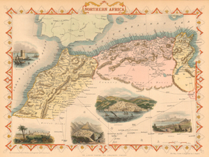
1851
1851 map
Tallis, John, 1817-1876.
“Northern Africa.” Steel engraved map, with some added color, 22 x 30 cm. From Tallis’s The Illustrated Atlas, and Modern History of the World, Geographical, Political Commercial & Statistical, edited by R. Montgomery Martin (London, 1851). [Historic Maps Collection]
Like the Tallis map of the African continent, this one blends cartography and imagery into an attractive visual sheet. Only the Barbary states of Marocco (Morocco), Algeria, and Tunis are represented; Tripoli is squeezed in at the right. Note that the “Country Abounding with Dates,” called Biledulgrid on many earlier maps, is situated further north than before. Actual caravan routes across the Sahara are drawn. A number of rivers running southeast from the Atlas Mountains are described as becoming “lost in sand.”
The wealth of place-names, the links between towns and villages, and the identification of specific mountain ranges introduces a more modern look to the mapping of this area. Colorful vignettes of the coastal ports of Mogador (now Essaouira in southern Morocco), Algiers, and Tunis, the fortified city of Constantine (in Algeria), and the major Moroccan city of Marocco (now Marrakesh) help travelers see Africa as a more attractive and (possibly) accessible destination.
