 Princeton
Mesoamerican Manuscript, no. 13
Princeton
Mesoamerican Manuscript, no. 13
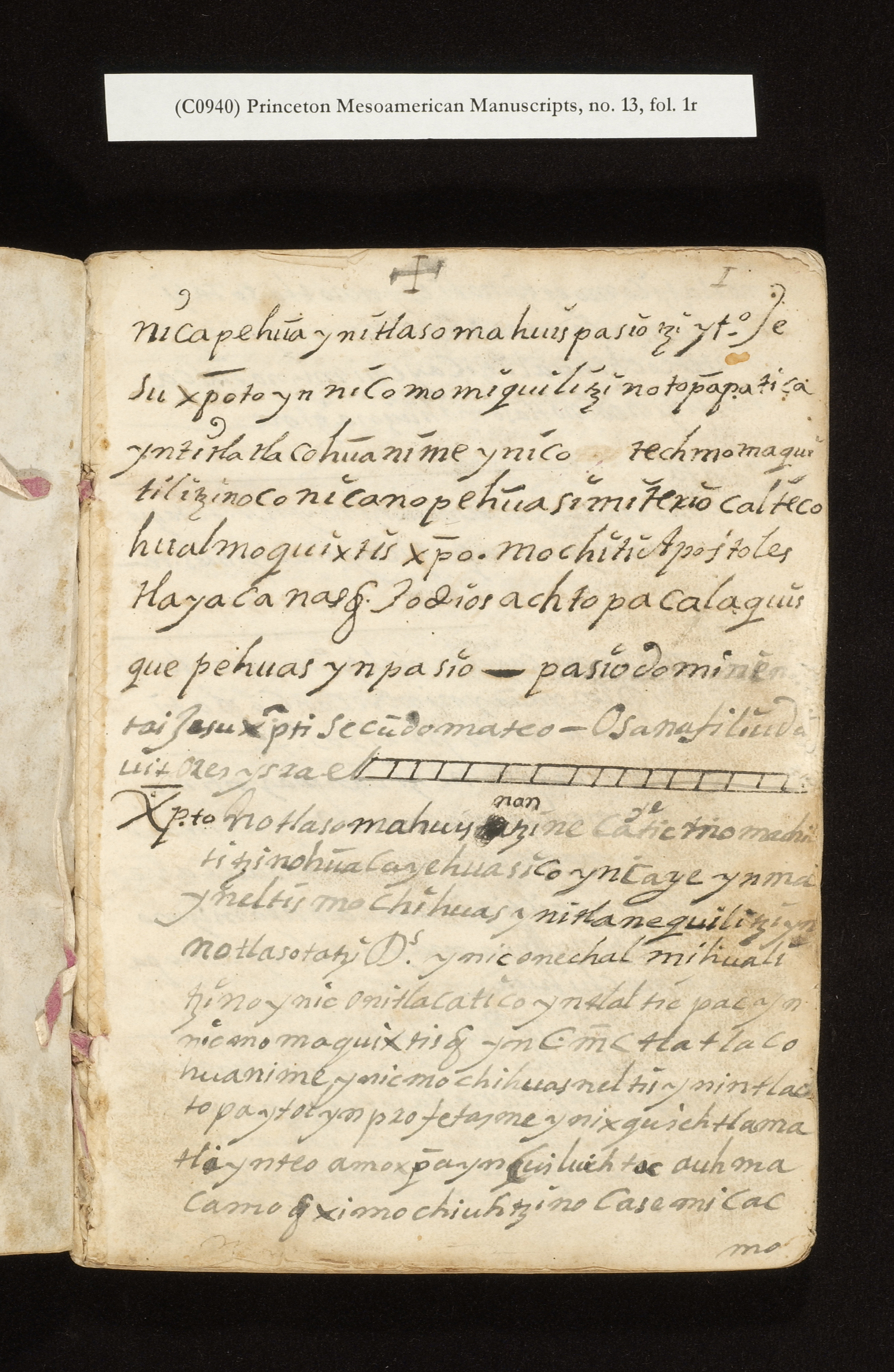
Title: Nahuatl Play
Date: 1800s
Language(s): Nahuatl with some Spanish
SCOPE AND CONTENTS
Manuscript copy of an unidentified Nahuatl play based on the life of Christ.
PHYSICAL DESCRIPTION
Material and Layout: Paper; 50 leaves; 21 x 16 cm.
PROVENANCE
"Propreidad del [P ] Canuto Flores ... Mx." and other inscriptions,
written in pen on back pastedown and back of wrapper. Purchased for Princeton
University Library (source unknown).
 Princeton
Mesoamerican Manuscript, no. 14
Princeton
Mesoamerican Manuscript, no. 14
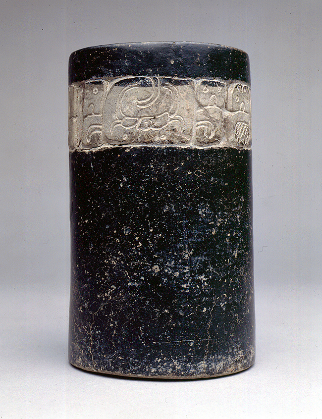
Title: Maya Vessel
Date: 600s
SCOPE AND CONTENTS
Maya bowl with a hieroglyphic text, as yet not translated. From Mexico.
PHYSICAL DESCRIPTION
Material and Layout: 1 item
PROVENANCE
Gift of Gillett G. Griffin, ca. 1970.
 Princeton
Mesoamerican Manuscripts, no. 15
Princeton
Mesoamerican Manuscripts, no. 15
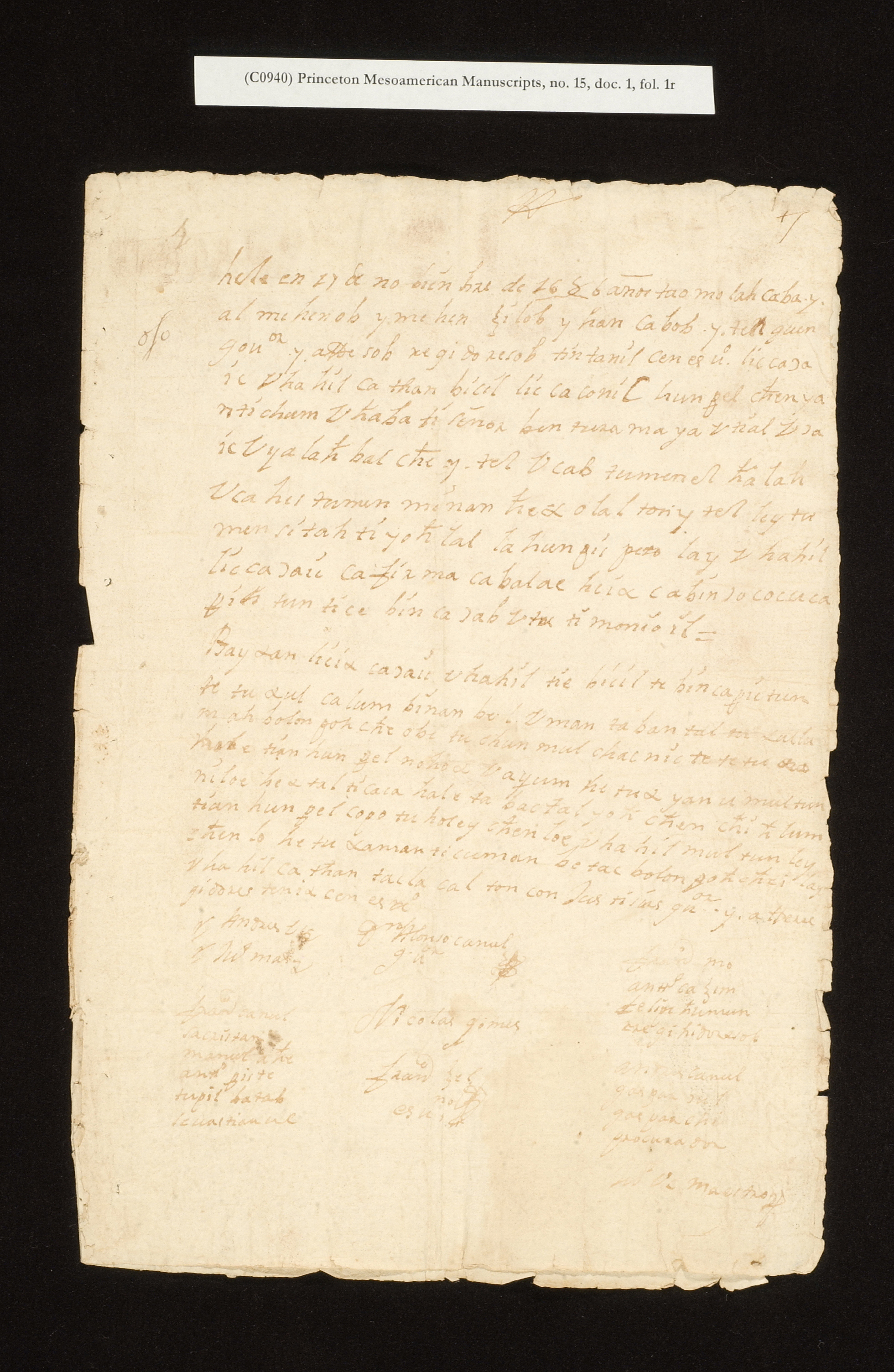
Title: Maya Legal Documents
Date: 1686-1849
Language(s): Nahuatl and Spanish
SCOPE AND CONTENTS
Miscellaneous legal documents from Mexico, 1686-1849. Seven of the sixteen folders of documents are from the Yucatan and presumably in Yucatec Maya, 1804/5-1849.
PHYSICAL DESCRIPTION
Material and Layout: Paper; 63 leaves; 32 x 22 cm.
Binding: Unbound sheets
 Princeton
Mesoamerican Manuscripts, no. 16
Princeton
Mesoamerican Manuscripts, no. 16
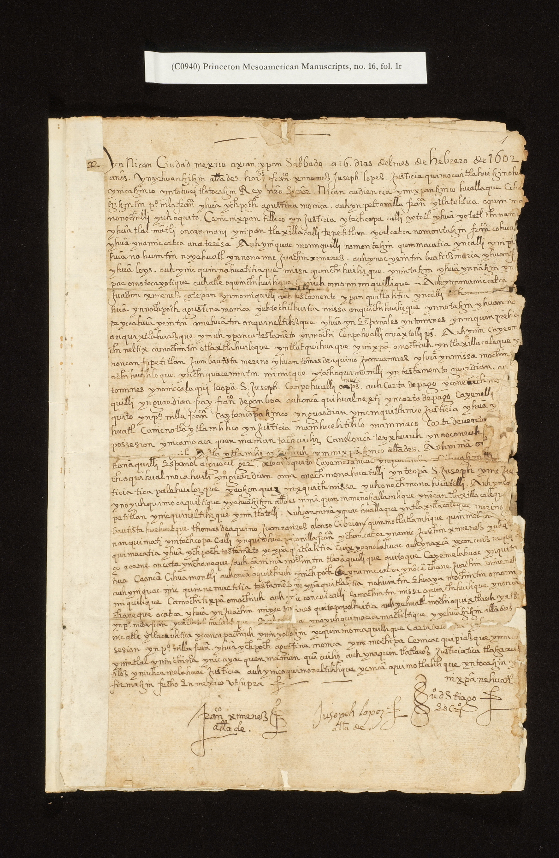
Title: Mexican Indian Land Transfers
Date: 1602-1849
Language(s): Nahuatl and Spanish
SCOPE AND CONTENTS
Bound volume of 15 land documents concerning the ownership of land and property at the address "Casa no. 13 del Callejon de las Cedaceras" in Mexico City. The volume begins with a notarial document of 1602 in Nahuatl accompanied by a required Indian pictorial land map. The later documents are in Spanish.
PHYSICAL DESCRIPTION
Material and Layout: Paper; 60 leaves; 31 x 22 cm. (mostly)
Binding: 19th century, quarter bound in calf
PROVENANCE
Purchased from Philadelphia Rare Books and Manuscripts, 3 May 2003 (AM 2003-121).
Author: Ramírez del Castillo, José
Title: Map of San Miguel Xaltocan
Date: 1726 July 2
Language(s): Spanish
SCOPE AND CONTENTS
Illustrated description by Ramírez del Castillo of the village of San Miguel Xaltocan, bishopric of the State of Mexico, Mexico. The text describes geography, politics, neighborhoods, and numbers of families in the town and it's component districts. Also describes various sacred objects of the local church and another church in San Andrés.
PHYSICAL DESCRIPTION
Material and Layout: Paper; 1 item; 54 x 43 cm.
PROVENANCE
Purchase, source unknown (AM 1978-29).
Author: Toad's Back
Title: [a Maya Huipil]
Date: 1992
Language(s): textile
SCOPE AND CONTENTS
A Maya (Tzotzil) huipil, or ceremonial shirt, from Magdalenas, Chiapas, Mexico, made with a woven symbolic design of mythological importance, accompanied by a description by Walter F. Morris, Jr.
PHYSICAL DESCRIPTION
Material and Layout: garment, approx. 34 x 36, folded, placed in box (20" x 20" x 2").
PROVENANCE
Gift, Estate of Thomas Baird, 1996 (WA 1996-166).
Title: Hacienda de Santa Barbara (Tlaxcala, Mexico) records
Date: 1553-1802
Language(s): Spanish, Nahuatl
SCOPE AND CONTENTS
Consists of a collection of approximately 200 notarial and other documents, in Spanish and Nahuatl, regarding the formation of the Hacienda de Santa Barbara (Tlaxcala, Mexico) estate. Among the early written documents is a 16th-century "map" of land that an Indian proposes to sell. This collection documents the Spanish exploitation of the laws and the native population and the resistance that the Tlaxcalans mustered agains the dominant social group. Because the Tlaxcalans had been the major ally of Cortes, they received special treatment under the law in the post-Conquest era, including the declaration of the entire province as off-limits to Spanish settlement. The ban was not effective as these documents attest, but they also demonstrate the active role that the Tlaxcalan indigenous government (cabildo) played in the 16th and 17th centuries in assuring that all sales of Indian lands were "by the book": the seller doing so in Nahuatl before an Indian or mestizo notary, proper town crying of the proposed sale, etc. The documents were originally housed in a contemporary limp sheep leather pouch, which has been kept with the collection.
PHYSICAL DESCRIPTION
Material and Layout: approx. 200 items housed in folders in 1 half-size archive box and 1 large, flat archival box (16.5" x 20.5")
PROVENANCE
Purchased from Philadelphia Rare Books and Manuscripts, 2008 (AM 2008-110).
Author: Anonymous
Title: [untitled Spanish manuscript]
Date: ca. 1590
Language(s): Spanish
SCOPE AND CONTENTS
Anonymous. Manuscript on native paper. In Spanish with native glyphs and drawings. [Mexico: ca. 1590]. Folio (40.5 x 30.5 cm; 13.75" x 12"), pp. 69-72.
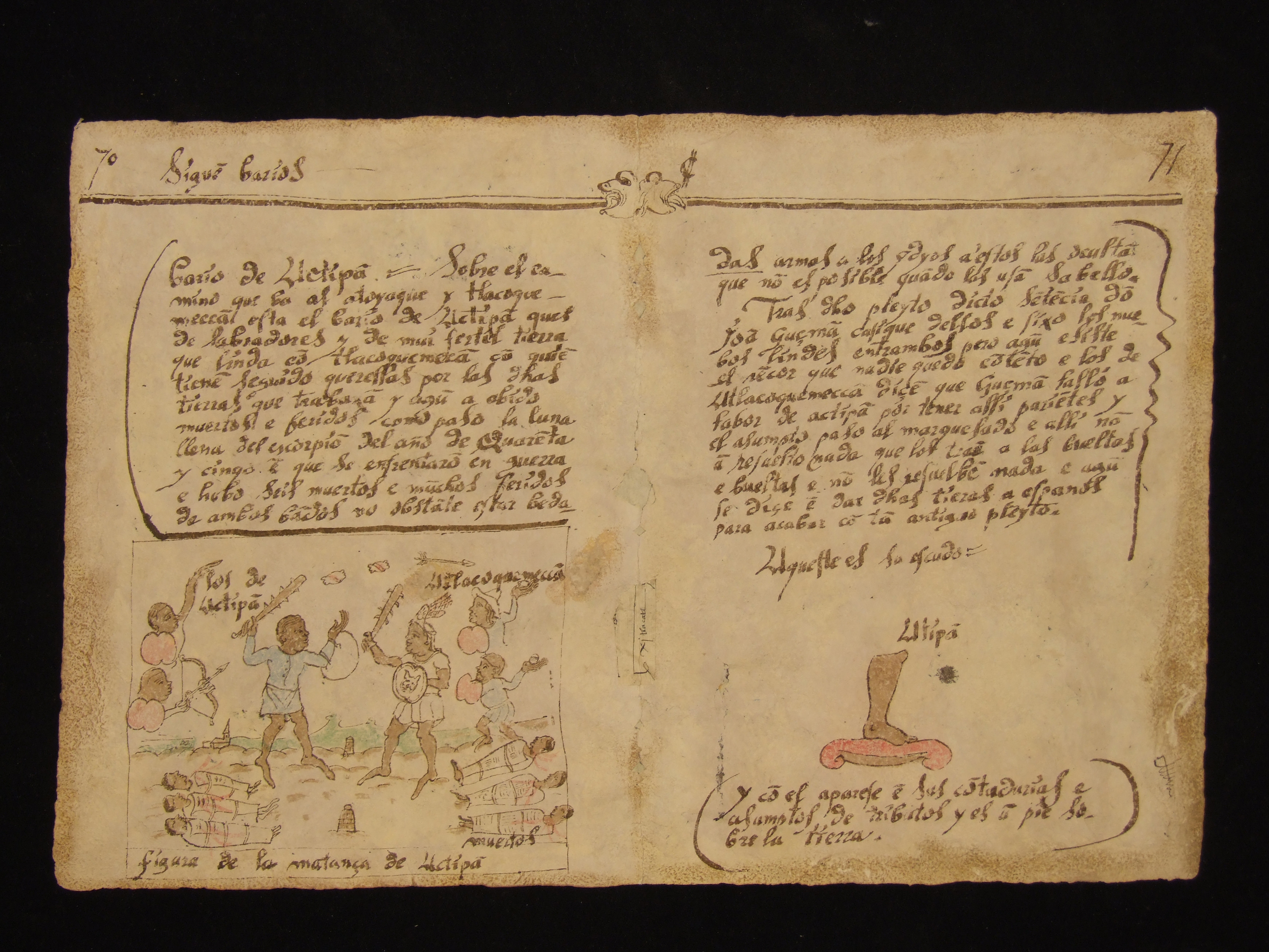
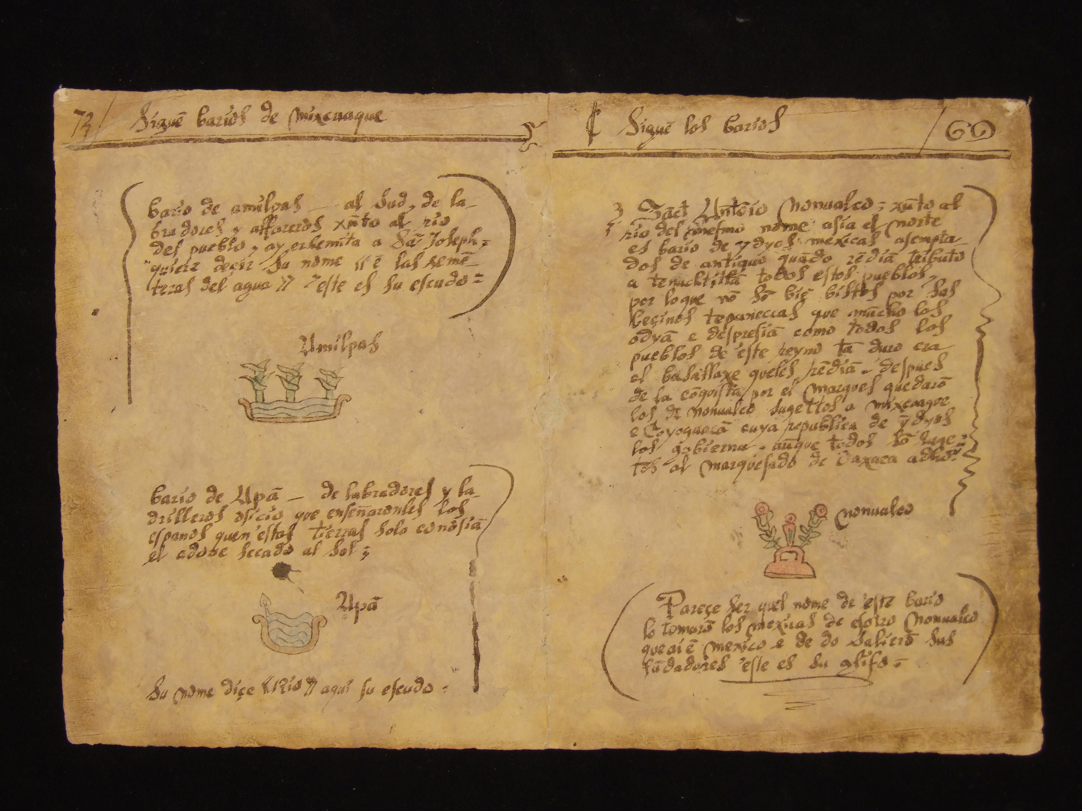
Either part of, or closely related to, the famous "relaciones geográficas" endeavor that the Spanish crown carried out in the late 1570s and through the 1580s (see: http://www.lib.utexas.edu/benson/rg/). Present on these pages are very brief accounts of the towns (i.e., "barios" [sic for "barrios'']) of San Antonio Nonoalco, Actipan, Amilpas, and Apan, all in the Mixcoac region. Each account of the town tells at a minimum what the principal activity/activities of the inhabitants is/are and gives the native glyph for the town, in color. The entry for San Antonio Nonoalco is typical: "San Antonio Nonoalco, on the banks of the river of the same name. Towards the north is the region of Mexica Indians, exempted in ancient times when all of these towns rendered tribute to Tenochtitlan. For this reason they are not well liked by their neighbors the Tepanecs, who much hatred and disdain them, as do all or the towns of this region. . . . After the conquest by the Marques [del Valle de Oaxaca] they--the Nonoalcans--remained under the jurisdiction of Mixcoac and Coyoacan, which Indian republic governed them, although they were subject to the marquesado of Oaxaca." Below is the glyph for "Nonoalco" in the Aztec writing system. Rather more exciting is the description for Actipan: "On the road that goes to Atoyoac and Tlacocmecan is the town of Actipan that is [composed of] field workers and the ground is very fertile that borders Tlacocmeca, out of which arise the disputes for the land that they work and thus there have been deaths and injuries, as happened during the full moon in Scorpio in the year [15]45 when they confronted each other in battle and there were six dead and many wounded on both sides." Below is a large (22.3 x 17.5 cm; 7" x 9") depiction of a battle scene in which the native wear a mix of indigenous garb and European (including hats) and with the dead clearly depicted. After a further discussion of the legal wranglings that followed, the town glyph is given. Fold tears at middle of the bifolium, with a repair using a piece of European paper with one word in Nahuatl in a 16th-century hand. Soiling at edges.
The manuscript’s old leather wrapper, kept in the same custom drop-spine box with the rebound manuscript, has three front and back flyleaves from a handwritten register, “Padrón general de Jocotepec” (1870), listing names of people in Jocotepec, Mexico, from Armilla to Ramo, as well as their place of origin, age, marital status, and occupation.
PHYSICAL DESCRIPTION
Material and Layout: 40.5 x 30.5 cm. (13.75" x 12")
PROVENANCE
Purchased from Philadelphia Rare Books and Manuscripts, 2008 (AM 2008-110).
 Princeton
Mesoamerican Manuscripts, no. 21
Princeton
Mesoamerican Manuscripts, no. 21
Author: Anonymous
Title: Titulos primordiales de la Hacienda de Buena Vista (alias La Archicofradía)
Date: 1672-1777
Language(s): Spanish
SCOPE AND CONTENTS
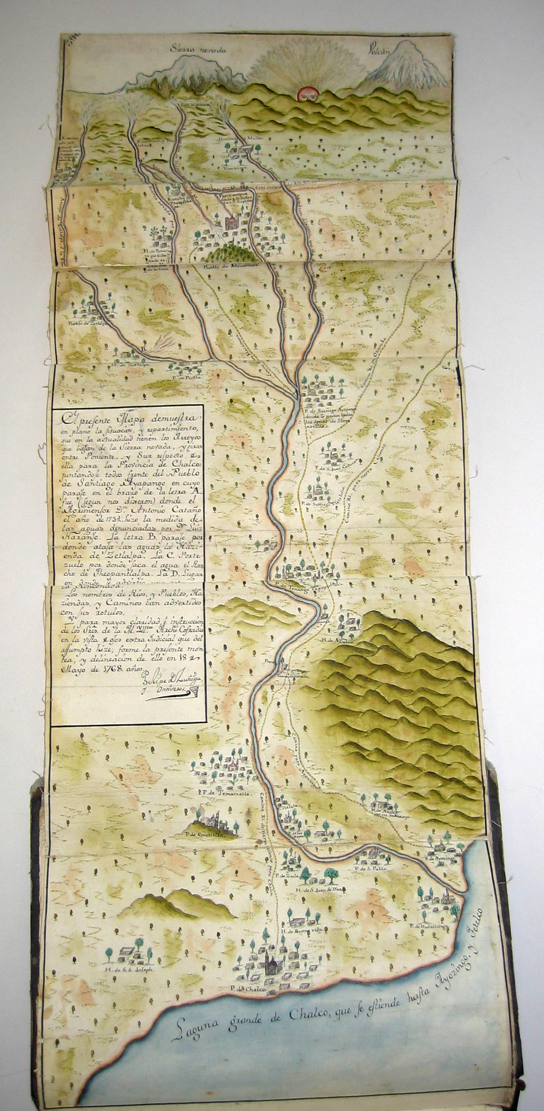
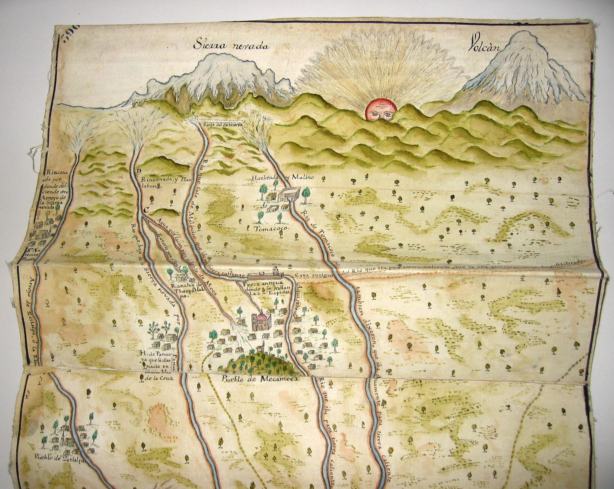
Folio volume of approx. 22 legal documents relating to land and water litigation in colonial central Mexico (not far from Mexico City), with 3-leaf manuscript index and five manuscript maps, bound in 19th-century quarter morocco and cloth. The maps are a 17th-century folding plan of the Pueblo de Chalco; another copy of that plan; another folding plan of Chalco, ca. 1734, with haciendas and ranchos handcolored and the hills of Cocotitlan in the distance; a handcolored map of the Province of Chalco with several pueblos and haciendas detailed, the rising sun and the Sierra Nevada depicted in the background, dated 1768; and a handcolored plan of the division of water between the haciendas of Assumpcíon and Buena Vista in the Province of Chalco. Among other pueblos represented on the maps are Pueblo de Mecameca, Pueblo de Santiago Ayapango, Pueblo de Temamatla, and Pueblo de Tenango Tepopula.
PHYSICAL DESCRIPTION
Material and Layout: paper, 448 leaves, 3-leaf index, 5 foldout maps; 33 cm.
PROVENANCE
Purchased at Bonham's Los Angeles sale of 15 October 2008 (AM 2009-46).
|
|
|
|
|
|